About IGNrando' – France hiking maps
IGNrando' is the National Geographical Institute's official app for outdoor activities in France. Find thousands of routes & never get lost with the best available maps. IGNrando’ is a French collaborative platform...
IGNrando' is the National Geographical Institute's official app for outdoor activities in France. Find thousands of routes & never get lost with the best available maps.
IGNrando’ is a French collaborative platform offering curated data and services related to outdoor activities.
RICH DATA OFFER
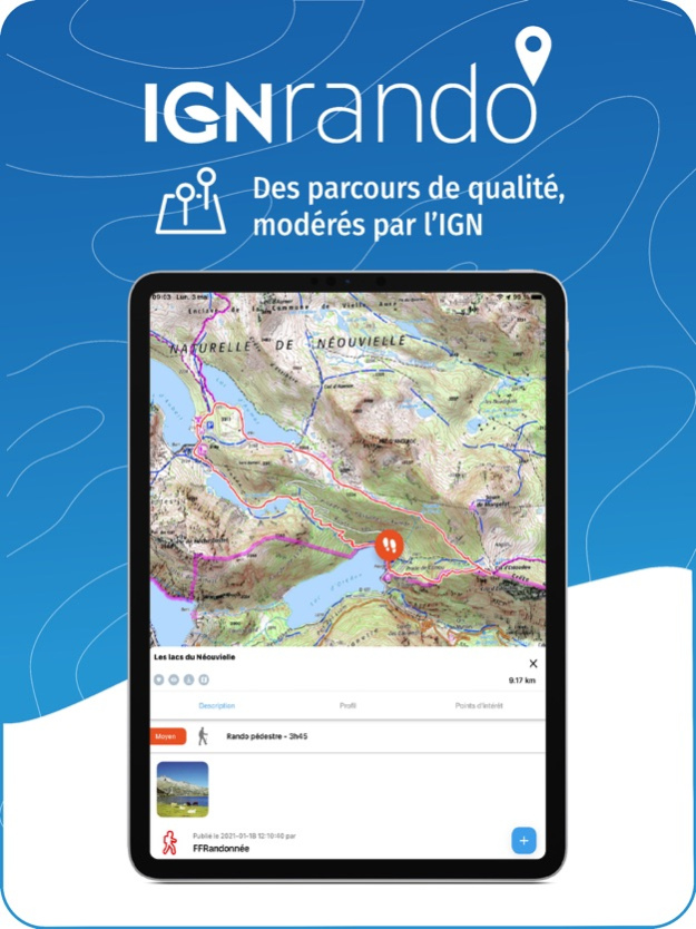
• Tens of thousands of available routes accross Metropolitan and Overseas France
• Choose the activity, difficulty and length to find routes around you or near any other place
• Download or mark as favorite the desired routes or POIs
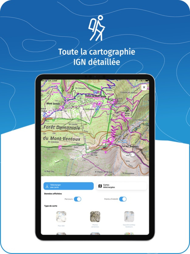
MAPS & LAYERS IN FREE ACCESS (with internet connection)
• Plan IGN: most updated map, suitable for all activities
• Aerial photos (IGN)
• OpenStreetMap Outdoors: world map with hiking routes & contour lines
• OpenCycleMap: world map with cycling routes & contour lines
∙ Spain IGN map
∙ Swisstopo map
∙ Emergency calls (112) mobile network coverage map for France
∙ OpenSnowMap
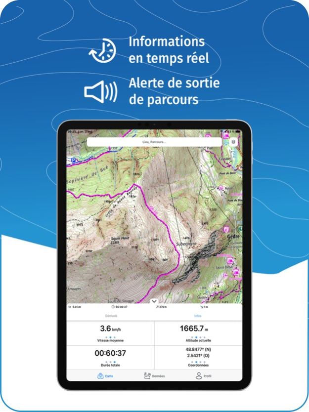
GPS GUIDING ALONG ROUTES
• See your progression on the map and on the elevation profile
• Get alerted if you exit the route
• Get notified of upcoming POIs or route info points (available soon)
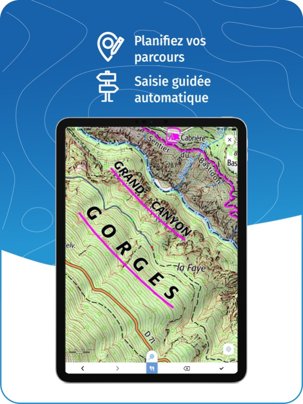
GPS TRACKING AND DATA CREATION
• Record your own routes using GPS
• Quickly create routes on-device with the automatic routing tool that follows roads and paths (online only, with subscription)
• Create Points of interest
• Export Routes or Points to save them locally (Files app) or share them
• Send your routes to ignrando.fr for backup or to publish them
OFFLINE USE
• The GPS keeps working even without internet: see your position on the map, use GPS guiding and record routes
• Downloaded routes: descriptions, photos and guiding remain accessible
• Downloaded maps (with subscription)
USEFUL TIP: Enabling Airplane Mode or disabling Mobile Data improves battery life, without affecting the Location Services (GPS)
IGN MAPS SUBSCRIPTION
• Create routes with pedestrian and vehicle routing
• View & download the following maps & layers:
∙ All free version maps
∙ IGN maps (various scales)
∙ IGN 1:25k topo maps (Top 25): the famous French topographical maps available at all zoom levels
∙ 1950 IGN maps
∙ Military maps (1820-1866)
∙ ICAO aeronautical charts
∙ France mobile network operators coverage maps
∙ Cadastral parcels layer
∙ DFCI grid (forest fire protection grid)
• Drones flight restriction areas
∙ Roads & paths layer (only available with Aerial photos)
IGNrando' store subscription
• Linked to IGNrando' account
• No automatic renewal
• Can be used on 3 devices at the same time
App Store subscription
• Linked to Apple account
• Automatic renewal unless cancelled at least 24 hours before the end of the current period
• Auto-renewal may be turned off by going to the user's Account Settings after purchase
• Any unused portion of a free trial period will be forfeited when the user purchases a subscription
WARNING: Ubicarta or IGN cannot refund subscriptions purchased on the App Store, only Apple can, at its sole discretion
ONLINE HELP (french only)
https://ignrando.ubicarta.com/help
FAQ (frequently asked questions - french only)
https://ignrando.ubicarta.com/faq
TERMS OF SERVICE
https://ignrando.ubicarta.com/terms
PRIVACY POLICY
https://ignrando.ubicarta.com/privacy
Apr 7, 2024
Version 1.49
• France mobile network operators coverage maps overlay
Previous Versions
Here you can find the changelog of IGNrando' – France hiking maps since it was posted on our website on 2021-12-16 18:59:30.
The latest version is 1.49 and it was updated on 2024-04-22 09:18:58. See below the changes in each version.
IGNrando' – France hiking maps version 1.49
Updated At: 2024-04-07
Changes: Apr 7, 2024
Version 1.49
• France mobile network operators coverage maps overlay
IGNrando' – France hiking maps version 1.48
Updated At: 2024-03-14
Changes: Mar 14, 2024
Version 1.48
• “Emergency calls (112) & SMS (114)” overlay
• Filters & new sort types for routes & points of interest
• All your published routes & points of interest are available (even if not added to favorites)
• Routes & points of interest are automatically downloaded on first open
IGNrando' – France hiking maps version 1.47
Updated At: 2023-10-06
Changes: Oct 6, 2023
Version 1.47
• Solves iOS 12 app startup issue (iPhone 5s & iPhone 6)
• Other bug corrections
IGNrando' – France hiking maps version 1.46
Updated At: 2023-08-26
Changes: Aug 26, 2023
Version 1.46
• Suggested communities
• User reviews for routes
IGNrando' – France hiking maps version 1.45
Updated At: 2023-08-07
Changes: Aug 7, 2023
Version 1.45
• Track editor for saved routes
• Improved IGNrando' account login
IGNrando' – France hiking maps version 1.44
Updated At: 2023-04-24
Changes: Apr 24, 2023
Version 1.44
• Choose the color and opacity of tracks
• Edit routes and points of interest
IGNrando' – France hiking maps version 1.43
Updated At: 2023-03-13
Changes: Mar 13, 2023
Version 1.43
• A "Help" section has been added in "Profile"
IGNrando' – France hiking maps version 1.36
Updated At: 2022-06-11
Changes: Jun 11, 2022 Version 1.36
• One extra zoom level for some maps
IGNrando' – France hiking maps version 1.34
Updated At: 2022-03-30
Changes: Mar 30, 2022 Version 1.34
• Interface fixes
IGNrando' – France hiking maps version 1.33
Updated At: 2022-03-25
Changes: Mar 25, 2022 Version 1.33
• Location sharing: share your location with your friends and see the friends who shared their location with you on the map
Disclaimer
Official App Store Link
We do not host IGNrando' – France hiking maps on our servers. We did not scan it for viruses, adware, spyware or other type of malware. This app is hosted by Apple and passed their terms and conditions to be listed there. We recommend caution when installing it.
The App Store link for IGNrando' – France hiking maps is provided to you by apps112.com without any warranties, representations or guarantees of any kind, so access it at your own risk.
If you have questions regarding this particular app contact the publisher directly. For questions about the functionalities of apps112.com contact us.